Landscape’ is not a reference to the physiognomy of the terrain. Rather, it evokes the possibilities and limitations of space: encompassing the physical land, the people on it, and the culture through which people work out the possibilities of the land. ‘Landscape’ means ‘existence.”
– David William Cohen and ES AtieNo Odhiambo1
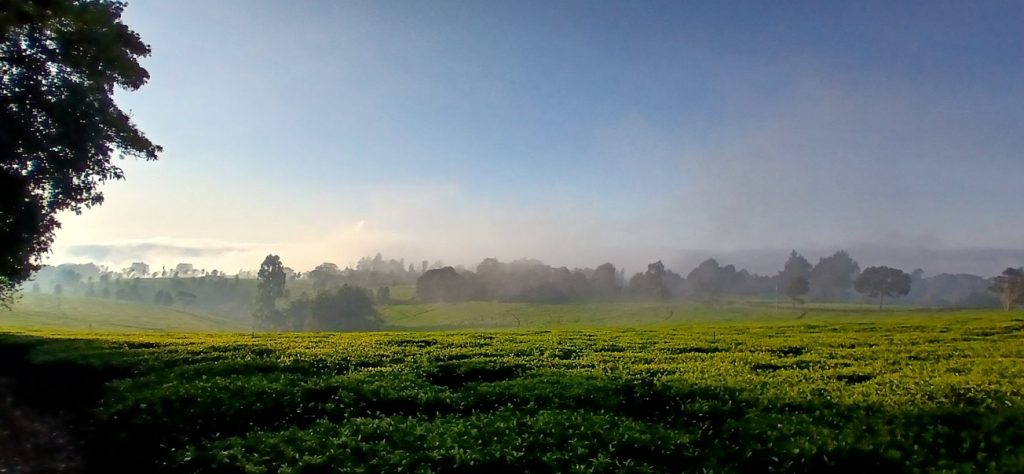
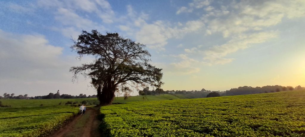
I grew up in Kenya. When I was a child, my family and I would occasionally visit friends in Tigoni. From our house, close to the Nairobi city centre, it wasn’t far – maybe 40 km. But we were a relatively sedentary family for whom weekends mostly meant the local swimming pool, where my father would do his lengths and my sister and I would jump off the diving boards. So, driving to Tigoni felt like an expedition. Tigoni is Kenya’s largest tea growing area.2 Look at it on Google Earth. It is an ocean of tea. It rolls on and on, as far as the eye can see, from horizon to horizon. I found it mesmerizing and awe-inspiring. So, four years ago, when my family and I returned to Kenya, we found a house to rent there, and moved in. It’s an old farm owner’s house nestled in a grove of indigenous trees. And all around it, the green ocean spreads out for miles.
What would pop into your mind if I said ‘landscape’ to you? The tea fields of Tigoni in the picture above surely qualify as ‘landscape.’ For me, as I imagine it would for many of you, landscape is vista – the expanse of land to the extent that the eye can see. Tigoni is beautiful, no?
But perhaps, when I say ‘landscape’ to you, another type comes to mind: the painting. When I was an undergraduate, one of our tutors – Brian Short, a cultural geographer – ran a class on how paintings could tell us something about what was valued at the time it was painted, the ways in which it was considered ‘beautiful’ and how paintings said things about how the world should be. The painting below, Stour Valley and Dedham Church, was painted in 1814 by the famed English landscape artist John Constable. What, my tutor asked the students, is ‘natural’ about it? He waited, as we all peered at the overhead transparency. (Yes, that’s how long ago it was.) I felt a little bad that I really liked it – I knew my tutor was taking us somewhere uncertain, but loving the painting was not, I guessed, the destination. It looked wonderfully peaceful to me. The air fresh and crisp. The sun warm, not hot. It was a landscape that was well managed, cared for. It looked orderly. But I didn’t dare say anything and kept my hand down.
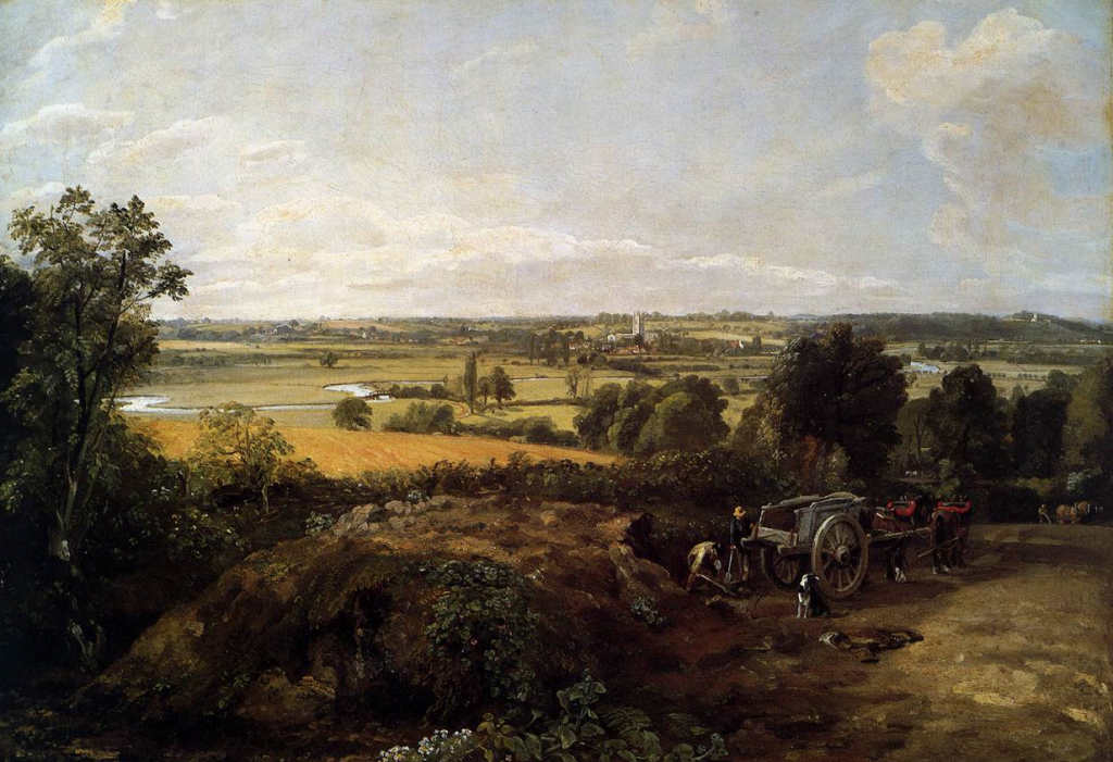
The geographer Ronald Rees has argued that Constable’s paintings are not neutral depictions of the world, but, rather, carefully composed geographical documents. Constable’s Dedham Vale and Stour Valley scenes depict intensively managed, enclosed, human‑modified landscapes, but present them as if they were natural and timeless. The effect is to normalize a particular agrarian order — enclosed fields, landed estates, water‑meadow systems — as the natural way an English landscape should look and function. This quietly affirms the power of landowners and the legitimacy of existing rural hierarchies.3 For John Barrell, Constable (and other English landscape artists) made the rural poor visually acceptable as part of elite décor: present, but small, marginal, idealized or aesthetically managed so that poverty, enclosure struggles, and class conflict are kept out of view. In this reading, Constable’s landscapes help mask relations of domination – they aestheticize a landscape structured by landlord power and agrarian capitalism, while making that power appear benign and ‘natural.’4 Constable wasn’t painting for the disempowered and the poor. He was painting for the empowered and rich, depicting the order they wished to see.
Many years after Brian Short’s lecture, I started work at an agency called the Mekong River Commission, an inter-governmental treaty organization at the time headquartered in Phnom Penh, Cambodia. The MRC had a strong hydropower focus – it devoted considerable attention to what was, at the time, a modest hydropower build-out in the Mekong River Basin (another landscape manifestation). It did not even occur to me that hydropower was anything but clean and green. Fast forward several years, and my mind has been utterly changed.
Hydropower developers like to offer their own Constables of their proposed dams. Below is one for the Hatgyi Dam, a behemoth that, if it goes ahead, will be built on the Salween River in Myanmar. Well-forested slopes descend to its reservoirs. In the bottom left, smallholders cultivate close to the dam wall. The reservoir’s water is placid, mirroring the immensity of the skies. In the foreground, a flock of white doves flies. The dam itself is not some concrete aberration, but sits in harmony with the landscape – it is an image that is benevolent and ordered. If a hydropower dam could possibly be rendered as bucolic, this is it.
Most renderings aim to deliver similar messages. But the Hatgyi is hugely controversial.5 If built, it would be located in the traditional territory of the Karen people, who have long resisted the political ambitions of Naypyidaw, the seat of the Bama-dominated Myanmar Union government. Like with many dams in the Mekong Region, proponents lead with the need for electricity (frequently a contentious claim) and the need for development (also contentious). What is not mentioned is that throughout the region, hydropower is frequently used as a strategy for state territorialization. Hydropower needs roads that lead to the site (along which the military can travel, followed by logging trucks and equipment), people have to be resettled (into ordered villages of ubiquitous housing, uprooting centuries of livelihood types, systems of land tenure, access to natural resources, etc.), and create ecological upheaval (fisheries destroyed, sediment loads trashed, flood regimes interrupted).
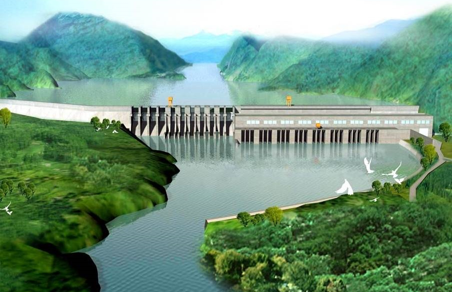
It is impossible to reconcile the image of the Hatgyi with the damage the dam will likely deliver if it is built. But the rendering above is its own form of propaganda, and even if computer-generated, sends out a message of legitimacy – one that speaks to reconciliation between concrete and nature, and to order. But in the same way that geographers have picked apart the nuances in Constable’s paintings, these envisionings are also suggestive of the sheer domination of hydropower over its landscape. “As gigantic manifestations of state power, dams can be seen as visualizing no less than a nation’s dream of centralizing and controlling its resources – and demonstrating it to the rest of the world.”6
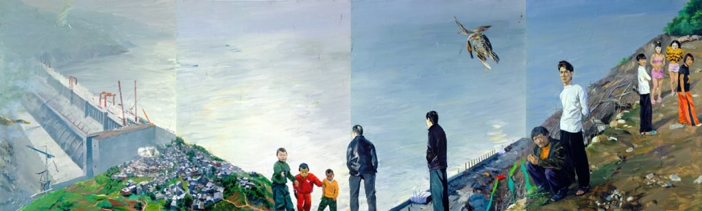
In deep contrast to this rendering of the Hatgyi is Liu Xiaodong’s painting of a Three Gorges dam nearing completion. This massive painting (3 x 10 m comprising four panels) is shrouded in an air of despondency – from the macabre little boys at centre, the two jacketed men staring at the dam, a second set of men staring at the viewer, and a tawdry scene at right which appears to be a negotiation for sex. And then, disconcertingly, there is the duck, shot by an unseen marksman, falling from the sky. And the whole is overwhelmed by a grey pall – the reservoir, the grey concrete of the immense dam and the grey detritus of a town that has been evacuated to make way for this technological shrine that exemplifies “the messy dialectics between creation and destruction inherent in Modernity’s Promethean project.”7
About 30 km north of Tigoni is the Aberdare National Park – a remarkable place. Its vegetation is best understood as a stack of altitudinal zones: lower montane forest, a bamboo belt, then heath, moorland, and Afro-alpine vegetation higher up. In the forest zone you find trees such as cedar, camphor, olive, Podocarpus, and Hagenia; in the middle elevations bamboo becomes dominant; and near the summits the landscape shifts to giant lobelias, Senecio, tussock grasses, and heather-like shrubs. The Aberdares – like Tigoni – are high up the escarpment to the Great Rift Valley – some 2,000 m and above. What the British found in Tigoni was Aberdare Forest, for it once extended all the way along the eastern wall of the Great Rift Valley.
The Kikuyu called this range ‘Nyandarua’ – this derives from the Kikuyu word rwandarua, meaning “a drying hide”, named for the distinctive fold of its silhouette. The first European to lay eyes on the range was Joseph Thomson, who, in 1884, saw fit to name it after Henry Austin Bruce, 1st Baron Aberdare, the then president of the Royal Geographical Society, which had supported Thomson’s expedition to East Africa. Meanwhile, the current Baron Aberdare (the 5th) sits in the House of Lords.
When the British had first arrived in Kenya, the Kikuyu people had been decimated. By the time the first surveyors arrived in Kiambu around 1900, perhaps 70 percent of the local population had died in the Ng’aragu ya Ruraya, the Famine of the Europeans, compounded by smallpox and rinderpest. To the British, the land looked empty. But it wasn’t; it was bereaved.
The Kinyanjui and Njiriri pioneer generations had established the southernmost kihingo (fortified pioneer villages) at Limuru and Uplands in the late 1700s – about a century before the Europeans arrived. This fact made the colonial ‘empty land’ claim slightly more plausible than for Murang’a (where Kikuyu settlement went back at least to the sixteenth century) and partly explains why Limuru was so heavily targeted for European alienation. It was the most recently settled, most thinly populated (because of the famine), and most legally vulnerable Kikuyu territory. In British colonial law, abandoned land was terra nullius, available for Crown alienation. The 1898–1900 catastrophe was not just background context: it was the precondition that made the alienations possible without provoking immediate organized resistance. By the time famine survivors returned, their land had been gazetted as Crown Land and granted on 99-year (later 999-year) leases to settlers.
In the early 1900s, the British began experimenting with tea cultivation in Limuru. The first commercial farm in Tigoni was the Kiambethu Tea Estate, established in 1910. It’s just up the road from where we live. Commercial expansion followed in the 1920s. But the Tigoni Kikuyu were not removed in a single act of seizure. Their dispossession was a quarter-century compression. From the early 1900s onwards, a stack of instruments was assembled around them: hut tax, then poll tax, demanding cash that could only be earned by working for Europeans; the kipande pass, tying men to specific employers; the 1915 Crown Lands Ordinance, which made everything outside the Native Reserves available for alienation; a sequence of squatter ordinances that progressively hollowed out the labour-tenancy arrangements on settler farms; commission after commission whose findings systematically declined to recover what had been taken. By the early 1930s, the Tigoni clans were surrounded – economically, legally, politically – and the offer that came was not a negotiation. It was the formalization of a process whose outcome had been determined 25 years earlier. They were offered 1.5 acres at Lari for every acre at Tigoni. The land at Lari is poorer, drier, on the lee side of the escarpment. Some accepted. Those who declined were forced out anyway, with no compensation. The first families arrived at Lari in 1939, the last in 1949. Lari is a little further up the road from us. It includes a southern extension of the Aberdares, the Gatamaiyu Forest. My son was up there on Friday to play paintball and go zip-lining. Eighteen years after the boundaries at Lari were drawn, Mau Mau fighters came down from the Aberdares and killed the loyalist elders who had drawn them – in an infamous moment, the Lari Massacre. The conditions for that violence were being assembled, decade by decade, along the road I now drive to work.
All around us is the sea of green. Its undulations are like swells, rising and falling. It’s beautiful, no?
As I walk the dogs through the tea, I cross a small river onto to a neighbour’s farm and look back. Our house is lost in the coppice of trees, but I can see the ‘tea lines’. Most of the tea farms around here have these: rows of white-washed quarters housing tea pluckers. In the mornings, as I leave the house for work, I drive down a short, muddy, bumpy track. Off to my left, I can see the pluckers working in the drizzle. Their hands move fast as they pluck pale green, almost luminous, leaf shoots, and toss these into tea baskets suspended on their backs. Just down the track from the house is what we call the ‘tea weighing tree’. There’s a piece of wire hanging from one of its branches, and on tea picking day, a scale is hung from the wire. When the pluckers come in, they each dump their tea out onto a piece of awning, the corners of which are then folded together, and the whole is lifted onto the hook of the scales. The weight is then recorded, and the pluckers head back out into the green sea.
Tea picking is crappy work. Standing in the rain, or under a hard sun, they work until they have picked a quadrant. The pay is abysmal. In rural Kericho, the ‘living wage’ is about US$224 per month. Average pay for tea pluckers is, however, roughly US$108 per month, below the minimum wage.9 In 2023, a one-hour BBC Africa Eye/Panorama documentary called Sex for work: the true cost of our tea10 documented testimony from over 70 women to systematic sexual exploitation by supervisors at plantations operated by Unilever (later Lipton/Ekaterra) and James Finlay & Co. in Kericho. The Fairtrade Foundation called it a #MeToo moment for tea.11
So, what is this landscape? As I drive home from CIFOR-ICRAF, I’ll often take the road that runs through Ruaka and its matatu traffic insanity; turn right onto the Old Limuru Road, and make my way up the hill through Banana, and lots more traffic insanity. It’s the shortest way home by distance, but arguably the longest timewise. I’ll then crest a ridge and suddenly the ocean of green unfurls in front of me, and the tension of dodging matatus hell-bent on killing me drops away like a slough. Further to the north, great cumulonimbus clouds gather over the escarpment, ready to release torrents on our little house and all that tea. The peace this vista brings is real, but guilty. As I look at it, I can also see Brian Short with his Constable overhead transparency. The beauty of the tea masks the very social injustices – past and present – required to produce and maintain it.
Before Alexander von Humboldt, European natural science worked through Linnaean taxonomy. It saw nature as a catalogue of discrete species, classified into hierarchies – life and living was taxonomizable. Von Humboldt referred to himself as a “scientific traveller,” a “physicist of the earth,” and a “practitioner of the physics of the world.” His central move was to insist that such taxonomizing was the wrong unit of analysis. What mattered was the web — the interconnections between climate, soils, vegetation, altitude, hydrology, animal life, and human activity that produced any given place. It was the inbetweenness of things that mattered. He called this the Naturgemälde, “the painting of nature”, and it’s the conceptual ancestor of pretty much every landscape diagram since. In Cosmos (Vol. 1) he writes “Nature considered rationally, that is to say, submitted to the process of thought, is a unity in diversity of phenomena; a harmony, blending together all created things, however dissimilar in form and attributes; one great whole animated by the breath of life.”12 And that, my friends, sounds a lot like integration.
Von Humboldt’s single most consequential image was the astonishing Chimborazo cross-section in his 1807 Essay on the Geography of Plants — a picture of the Chimborazo volcano (in Ecuador) showing vegetation zones stacked by altitude, with parallel columns recording temperature, pressure, humidity, and species distribution. It’s the prototype of biogeographical thinking, and arguably the prototype of landscape ecology as a visual practice. If you’ve ever drawn a transect, or a stacked diagram with elevation against species or land use, you’re working in Humboldt’s direct lineage.
Von Humboldt rejected the Cartesian and Linnaean tradition that placed humans outside or above nature. In Cosmos (Vol. 1), he describes nature as “one great whole animated by the breath of life.” Humans are part of that whole, not external to it. He argued that any physical description of the world had to include human cultures, languages, and politics as constituent elements. Von Humboldt was probably the first European scientist to articulate, on the basis of empirical observation, that human activity was a geological-scale force capable of altering climate, hydrology, and ecology at regional and potentially global scales. He’s the founding figure of what we now call Anthropocene thinking, more than 150 years before Paul Crutzen coined the term.
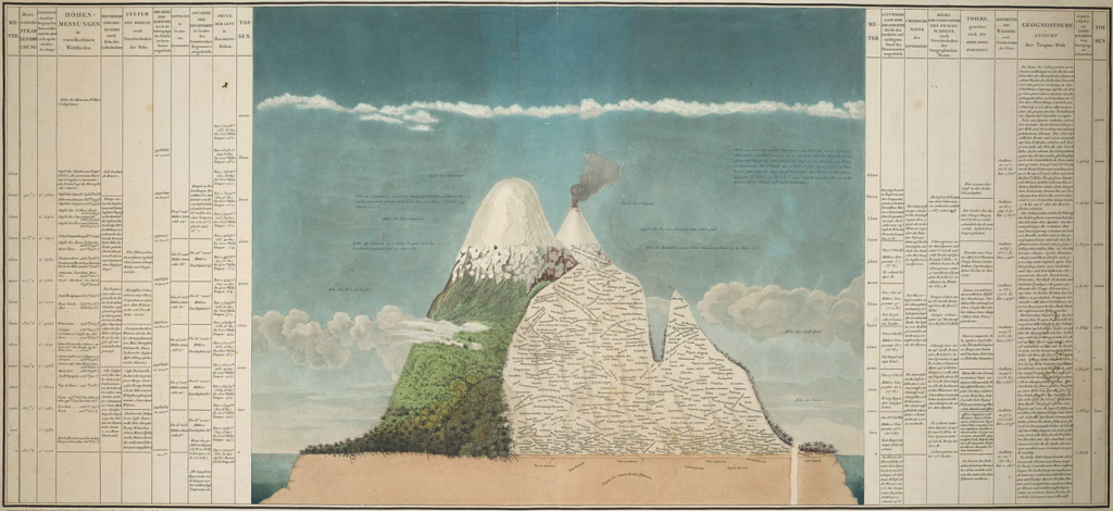
The reason I’m getting into Von Humboldt is because (a) he’s a really cool guy; and (b) because of that Naturgemälde – the nature painting. As I crest the ridge on the way home from work, I’m trying to read the landscape before me as Von Humboldt’s rendering. His Chimborazo cross-section did not include human influences or dimensions, but it inspires me. I could start the transect on the floor of the Great Rift Valley at Naivasha (semi-arid grassland, around 1,890 m) up the Kikuyu Escarpment through montane forest at Tigoni (2,100 m) up to the bamboo zone in the Aberdares (2,500–3,000 m) and on to the Afro-alpine moorland at the Aberdare summits (above 3,500 m). Textbook Humboldtian Naturgemälde. But how do we paint that picture to include those human influences? How do we capture, in visual form, humanity’s ecological authoritarianism?
In May 1950, the Aberdare National Park was gazetted by the Kenyan colonial government. This was in the immediate run-up to the Mau Mau Emergency (declared in October 1952). The colonial state gazetted the upper-altitude forest as a protected area at exactly the moment when Kikuyu landlessness in Kiambu had become acute, when squatter expulsions from the Rift Valley were dumping dispossessed families back into already-saturated reserves, and when the political organizing that would become Mau Mau was intensifying. The park’s establishment took the Aberdare montane forest — historically used by Kikuyu mbari (clans) for hunting, beekeeping, ritual sites, building materials and as a strategic land bank — out of African use entirely. Combined with the existing Crown Land status of much of the lower-altitude forest, this meant that by 1950 the Aberdare ecosystem was almost entirely closed to the Kikuyu communities who had been its closest human neighbours for centuries. It was here that the Treetops Lodge was built, and where Princess Elizabeth was watching elephants at the salt-lick below the lodge when her father, George VI, died and she became queen.
At the start of my career, I worked on a large EU-supported project called the Lake Victoria Fisheries Research Project (we provide another anecdote from this project in the Unstated Intent Section). The objective of this project was to create a management plan for the fisheries of this immense lake in partnership with the fisheries research institutes in the three countries that shared it, along with their fisheries departments.
Most of the project’s sizeable budget was focussed on fish stock assessment and biology. I found this a little mystifying. If the plan was supposed to manage how people fished – the gear they used, where they fished, when they fished, etc. – then why was almost all of our budget focussed on fish stocks? Fish stock conditions served to amplify human practices and were in turn caused by human practices. Fishermen (only men fished) didn’t go to fishing grounds where the stock had disappeared – which their fishing intensity had in any case caused. Every tenet of the old fisheries regulations in the three countries was practice-focussed: gill-nets of under five-inch mesh-size were banned; Tilapia below a certain size had to be released. Traditional fishing methods were fine, etc. I was in charge of the “socio-economic” aspects of the project. After several years of work amongst the lake’s fishing communities, we were clear: if fishing practices were to be changed, knowing the size of the fish stock wasn’t particularly pertinent. Fishermen knew where fish stocks were, knew when they were low, knew that average fish sizes were decreasing, or that landings were also declining. The principle of a fish stock under serious duress did not need fish stock assessments to confirm it.
I made this argument at one of our multiple workshops to discuss the drafting of the plan. “No!” thundered the director general of one of the fisheries research institutes. “All fishermen are liars! These people cannot be trusted.” Which explained why so little of the budget was devoted to researching fishing communities. It was also an explicit recognition of something that I had noticed in all of the fisheries research institutes: in all cases, the “socio-economic” teams were tiny – everyone else was biophysical. And the supremacy of this latter knowledge type was clear. Science would establish the state of the fish stock. In turn, this would inform the fisheries management plan. In turn, this would indicate what regulations were required. And, in turn, this would furnish the three fisheries departments with the legal authority they needed to implement and police them. Small matter that every single one of our surveys catalogued how corrupt fisheries officers were and that these very regulations provided them with the discretionary powers they needed to extract bribes, seize nets and catches for resale. And in the end? The fisheries management plan we generated banned gill-nets of under five-inch mesh-size; Tilapia below a certain size had to be released. Traditional fishing methods were fine, etc. Our project coordinator was sympathetic to my grumbling. But the plan, he argued, was the only one that was politically possible.
Liz Wily’s argument about African community forestry was working in the same direction.13 She showed that a focus on granting local people use rights to forest product – fuelwood, Non-Timber Forest Products (NTFPs), limited timber – but keeping real decision‑making power in the hands of the state forest service doesn’t work if what you’re aiming for is forest conservation. Instead, what’s needed is devolving power, not just recognizing use. This completely resonated with my read on Lake Victoria’s fisheries. If her work was on forests, and mine on fisheries, did this not then mean that the resource in question was basically redundant? Not totally. The resource’s characteristics will, of course, affect human practices – fisheries practices have little meaning to people collecting NTFPs. But the practices – whether those of small-scale communities, corrupt fisheries/forestry scouts, hydropower developers, or researchers – seemed to me to have far more relevance to how resources are managed than the resource’s biophysical condition – the latter was a symptom of something else, something that – to the best of my knowledge – was rarely addressed in natural resources management. It was as if the idea of integration was being forgotten in the same moment that it was being spoken about.
The painting that is Tigoni continues to change. In his rendering of Chimborazo, Von Humboldt, it seems to me, was not able to incorporate the power of human intervention into the image. But, oddly, I think Constable was. Whatever it was that he saw as rustic, bucolic, peaceful, and timeless was the manifestation of a type of power he approved of. I don’t doubt that Constable poured affection into his work. “Painting,” he wrote to a friend “is but another word for feeling.” And the power that his paintings rendered was one that he loved. And you can see it.
I’m walking down a street in Brussels with my team and our colleagues from the European Commission. One of our EC colleagues and I are discussing our recent advances in thinking about Integrated Landscape Management (ILM). He comments that it makes him think of terroir – an idea that derives mainly from vine-growing. I’m ashamed to say, I had never heard of this concept. After dinner, I hurry back to our Airbnb and begin investigating. Our EC colleague was right to bring this up, because it’s an excellent concept.
Terroir is a contested term, I learn. The official position of France’s Institut National de l’Origine et de la Qualité and the legal foundation of the Appellation d’Origine Contrôlée system defines terroir as, basically, the unique intersection of soil + climate + topography + grape. This formulation, repeated in every introductory text on French wine, treats human practice as either irrelevant to terroir or as something separate that ‘expresses’ terroir without being part of it. The winemaker is the medium; terroir is the message.
But! Others would argue this is a contested cultural construction, a hegemonic discourse that simultaneously naturalizes and erases the human labour that produces it.14 The Organisation Internationale de la Vigne et du Vin (the international wine body) agrees. In 2010, it adopted a new official definition that explicitly incorporated the human dimension. Terroir, they say, is “an area in which collective knowledge of the interactions between the identifiable physical and biological environment and applied vitivinicultural practices develops, providing distinctive characteristics for the products originating from this area.”15 Here, human practice is constitutive, not external. Terroir is no longer a thing (a piece of land with soils and climate) but a site of collective knowledge-formation about the interaction between environment and practice.
A merging, a fusion, or entanglement. Every sip of wine can impart the humanity – tradition, culture, praxis – that went into creating it. Liquid embodiment.
This is not a million miles from the ways in which the Chinese produce their tea. The biophysical environment is sharply differentiated and recognized as such. Specific tea cultivars are tightly associated with specific places — Longjing (Dragon Well) with the West Lake hills around Hangzhou; Bi Luo Chun with Dongting mountain on Tai Hu in Jiangsu; Pu’er with the old-growth tea forests of southern Yunnan, etc. The same cultivar grown in a different place produces a different tea, and trained Chinese tea-tasters claim to be able to identify provenance blind, much as wine tasters claim to do. The geomorphology, soils, altitude, mist regime and aspect all matter, and Chinese tea culture has names for these terroir-elements going back centuries.
The applied practices are extraordinarily elaborate and place-specific. Chinese tea is unique among the world’s tea traditions in producing all six tea categories (green, white, yellow, oolong, black, dark/post-fermented) from the same plant species, Camellia sinensis, through different processing techniques. Each category has its own processing protocol — withering, bruising, oxidation, fixing, rolling, drying, roasting, ageing — and within each category there are place-specific variations of remarkable subtlety. The processing is not just transformation of raw material; it is a major determinant of what the tea is.
But, back in Tigoni, tea is a mass production commodity. Oh, that it embraced something similar to the Chinese! That the green ocean was a mosaic of smallholders, each bringing to bear their knowledge, handed down from their parents, each packet of tea signalling its origin and the creativity and tradition that went into producing it. But it is not so. Tigoni’s tea was forged from colony, dispossession, enclosure – interventions that served to disintegrate an elaborate, functioning, commons system of land use and tenure.
The pre-colonial Kikuyu gĩthaka (pl. ithaka) was the mbari estate. It is one of the cleanest historical examples of an integrated landscape-and-practice tenure system that functioned as a commons — with bounded membership, layered access rights, redistributive obligations, deliberate forest reserves, intergenerational accountability, and elders’ council governance — and not the open-access resource that the colonial state believed it had found.16 The gĩthaka’s history was the mbari’s history, with origin narratives recounting how the founding ancestor had acquired it. The crucial principle Leakey emphasized, and Muriuki later confirmed, was that any mbari member with more land than they needed had a positive obligation to share with members who genuinely lacked it — at minimum through cultivation rights. The system included a strong redistributive ethic that made it function commons-like even though the underlying tenure was lineage-based.
There is a two-way infusion (to use a tea-based term) between humanity and the resources it relies on. I’ll accept that humanity does not determine tectonics. It’s what humanity does with tectonics that matters here. And I revert to my earlier point: why, if we’re trying to change the way people exploit fish, do we study fish? Why, if we’re trying to change the way people use a forest, would we send in a battery of dendrologists? Why, when we worry about how water is governed (by humans), would we task hydrologists with the responsibility of changing this? And, as arguments for the recognition of a new geological epoch acknowledge, the relationship between humans and the surface of the Earth is not an equal one. Ergo, the Anthropocene acknowledges who has the upper hand in this tense relation.
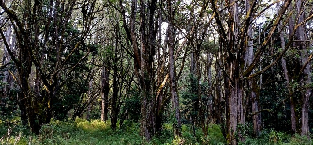
The dogs and I continue walking down the track, to where there’s access up into the tea. Just here, there’s a bank of exposed red earth. The bee-eaters burrow tunnels into it, where they nest. We stop and watch, hoping to see one of these brilliantly coloured creatures emerge. But none do. The adults are all perched on twigs from the Eucalyptus stands opposite. That’s another dimension, of course – vegetation as colonisation. The British brought the Aussie blue gums here; and the Aussie silver oaks – on our farm, they’re used as windbreaks. I head up the path, our Great Dane trotting ahead of me, the Dachshund shooting off under the tea bushes, looking for the source of rustles. About a hundred metres on, we come to a circular clearing. It is here that there used to be a HUGE mūgumo tree. The tree is a strangler fig (Ficus thonningii if we’re going to be Linnaean). It climbed up another tree, using it as a crutch to reach into the sky and towards the light, before strangling the life from it. Its long tendril roots reached to the ground and took root; the gaps between them gradually filled until an impressive trunk was grown. But in the centre, these trees are usually hollow – the void where the original tree stood. On the far side of this one, there was a ‘cave’ – a gap that had never filled, that allowed us to crawl in and stare up into the cavity above us. When we walked the dogs, we’d often stop here and rest amongst its roots and look up at its enormous canopy. It was truly a remarkable tree.
The farms around here all have lots of mūgumo trees on them. In Tigoni, they’re fairly common. And there’s probably a reason for that – chopping these down to clear the way for tea was, even in the estimation of the colonists, a step too far. The mūgumo is the surviving architecture of a cosmology in which land, lineage, ritual and authority were a single integrated system.[17] Ngai, the Kikuyu supreme deity, was understood to dwell on Mount Kenya — Kirinyaga, ‘the place of brightness,’ named for the snow on its peaks. The deity, the mountain and the people were not linked by relationships; they were aspects of a single complex. Homesteads were built with doors facing Kirinyaga; the dead were buried facing the peaks; the first humans had been brought together by Ngai beneath a mūgumo at Mũkũrwe wa Nyagathanga in Murang’a, and from their nine daughters descended the nine Kikuyu clans. The elders met under the mūgumo, sacrifices were offered to Ngai and oaths sworn. The boundaries of gĩthaka were marked by mūgumo.
To be alienated from the gĩthaka was therefore not just to lose economic resource. It was to be separated from one’s grandparents, from the place where one’s lineage was founded, from the architecture Ngai had provided for prayer. Even the name ‘Kikuyu’ derives from this fig-name root, gĩkũyũ meaning ‘big fig tree’ — the Kikuyu are, in this etymology, the people of the big fig. The colonial dispossession was a theological catastrophe at the same time as it was an economic one.
The trees dotted about in Tigoni’s tea are probably residual gĩthaka markers that predate the arrival of the British in Tigoni. Wangari Maathai wrote movingly about mūgumo trees in her memoir Unbowed — they were central to her childhood in Nyeri and to the Green Belt Movement’s symbolic vocabulary.
But then we had a great storm. The roots of the mūgumo are radial and not tap. Its girth is so considerable that it is this wide base that keeps it upright, and not the depths to which its roots penetrate. Overnight, as winds howled, it keeled over. When we found it, I stood and looked at it, feeling the implications of this collapse across the tea fields. Smaller ones survived – in fact, across the fields that the dogs and I marched, we saw no other trees had collapsed.
When a mūgumo tree dies, it is said to be the end of an era. The Kikuyu seer Mugo wa Kibiru had predicted that British settlers would leave if a certain mūgumo tree in Thika died. His words worried the British, who feared the resultant symbolism should the tree die. They protected that tree with a reinforcement of metal bars and an iron ring packed with soil – the remains of which are still in Thika. But the tree was struck by lightning in 1963, the year of Kenya’s independence.18
And so, in this sea of green, the mūgumo remain as cultural islands. It’s beautiful, no?
With the Kikuyu under such massive pressure, the establishment of the Mau Mau really should not have been the surprise that it seemed to be to the British. The irony with the formation of the Aberdare National Park was that it became a Mau Mau redoubt. In 1954, they burned down the Treetops Lodge, just eight months after the princess had become queen there. Between 1953 and 1954, the British bombed the hell out of the Aberdares, concentrating on the ‘Salient’ – an eastward projecting ‘arm’ of the park. By 1956, the Mau Mau were broken, but one leader, Dedan Kimathi, was still on the run, hiding in the Aberdares. On his tail was a police officer, Ian Henderson, who was on an “obsessive hunt” to capture or kill his quarry.19 Henderson wrote an account of his hunt for the Mau Mau leader, “the astounding story behind the capture of the most brutal and fanatical of all Mau Mau leaders.” “Long after the backbone of the uprising had been broken, he [Kimathi] remained at large, wandering through the dense forests with his formidable bodyguard of half-crazed thugs. There could be no peace while he was free to kill and pillage.”20
Bombing the Aberdares had not killed the man, so Henderson reverted to analysing his movements and practices through various interrogations with Mau Mau detainees. He learned that Kimathi prayed daily under a mūgumo tree. But which one? Henderson mapped out all of the mūgumo trees in the Aberdares – some 40 trees – and then selected a subset of eight particularly large ones that he judged Kimathi might approach, and then staked these out. The stakeout itself was protracted and grim: the soldiers began their stakeout for Kimathi, hoping that the freedom fighter would ‘favour them with a visit.’ On the forest floor, nobody moved, or talked. “In those same positions, the calls of nature would be answered by turning slowly on their backs and scraping a small hole in the soft, forest soil with their fingers.'”21
The stakeout failed. In the end, Kimathi emerged from the forest on October 21, 1956, two months after the stakeouts had collapsed. He had been forced out by hunger and the steadily shrinking circle of safe ground, and was caught at the forest edge near Ihururu in the Kikuyu Reserve, well outside the area where Henderson’s mūgumo operation had been concentrated. While trying to flee, a Kikuyu Tribal Police Officer, Ndirangu Mau, shot Kimathi in the leg. The British made much hay of his capture – while also trying to obscure the fact that it was Ndirangu Mau, rather than Henderson, who had caught the insurgent. Kimathi was executed at Kamiti Prison on 18 February 1957.
The colonial state recognized, accurately, that landscape and religion were intertwined for the Kikuyu — that the sacred fig was not just a tree but a node of meaning in a relational landscape. Henderson’s operation was, in its own way, a sophisticated piece of cultural intelligence work: he understood that Kimathi’s military survival depended on his ritual life, and that his ritual life depended on specific trees in specific places.
But the operation also expressed the limits of that recognition. Henderson could map the mūgumo, but he could not predict which one Kimathi would visit, because the choice was not random and not externally legible. Kimathi’s relation to particular trees was a relation he had with Ngai (God), mediated by a lifetime of Kikuyu ritual practice that no map could capture. The colonial cartographic gaze could see the trees but not the wood – their meaning. The 40 mūgumo on the map were not, from a Kikuyu standpoint, equivalent locations to be statistically sampled.
The mūgumo the British failed to find was, in some sense, the same kind of object as the gĩthaka the British failed to recognize in 1900 – a node of African meaning that the colonial gaze could see but could not read. Henderson’s map of 40 fig trees and the 1903 surveyors’ map of ‘empty land’ are pieces of the same colonial document, separated by half a century but executing the same misreading.
Von Humboldt’s work resonates through the centuries. Geography has long recognized that spaces (of whatever kind – including landscapes) are integrated wholes. The Humboldtian Naturgemälde was a first attempt; the early-twentieth-century plant-community concept was the second; assemblage theory, drawing on Deleuze, Guattari and DeLanda, has been the most recent. Assemblage thinking has done genuinely useful work – it has insisted that landscapes are heterogeneous, multi-scalar, materially-and-symbolically constituted, and always partially in transition. But it has also struggled to generate operational vocabulary for practitioners trying to manage actual landscapes, and has sometimes flattened questions of power into an undifferentiated heterogeneity.
Our ILM Playbook takes a different turn. Where assemblage theory describes, systems thinking – particularly systems thinking informed by complexity science – describes-in-order-to-intervene. Systems language gives us terms for states, transitions, leverage points, feedback loops, regime shifts, and emergent properties that practitioners can actually work with. It also has a longer track record of holding political-economic questions at the centre of the analysis rather than at its margins.
We adopt systems language for the Playbook not because assemblage theory is wrong, but because the work the Playbook is trying to do — supporting people who are trying to govern landscapes well, in real time, with real consequences — is better served by a vocabulary that has been tested against management practice for half a century. Humboldt’s wager was that landscapes could only be understood holistically. The Playbook’s wager is that complexity-science-informed systems thinking is the most operationally useful contemporary vehicle for that holistic understanding.
Importantly, systems thinking is not the property of Northern complexity science alone. Arturo Escobar’s Designs for the pluriverse (Colombia), Vandana Shiva’s Monocultures of the mind critique (India), Catherine Odora Hoppers’s argument for cognitive justice (Uganda/South Africa), and Maturana and Varela’s Autopoiesis and Cognition (Chile) are formulations the Playbook is in dialogue with — different vocabularies for the same project of recovering integrated ways of knowing the world against the reductionist forces that systematically dismantle them.
This choice — systems thinking over assemblage — is not just methodological. It is also political. The integrated landscape work the Playbook supports takes place, more often than not, in territories where the post-colonial state is itself a continuation of colonial dispossession under new management. The Tigoni I drive through every day was alienated by the British, and is now being re-alienated by Kenyan elites – different landlords, similar logic. The pluckers in the tea lines are paid below the minimum wage by companies that are no longer Brooke Bond but are still, in too many ways, Brooke Bond. The state that gazetted the Aberdares for conservation in 1950 and then bombed it, now fences it with 400 km of electrified perimeter – same enclosure, different equipment. Integrated landscape governance, in this context, cannot treat the state as a neutral integrator. The systems-thinking vocabulary the Playbook adopts treats the political-economy of who controls a landscape as constitutive of the analysis, not as background. Which brings me to a final stretch of road.
In Tigoni, the strands of practices – of the things that people do, and have done – reach into the present. I drive carefully between several badly parked cars on the edge of the tea. Their occupants are taking photos of each other, the tea as backdrop. “It’s beautiful, no?” I hear one call to her friends. As I turn onto the track leading to the little house, kids who live in the tea lines opposite scream and wave at me. Their voices are lost as the green ocean closes in behind me. I stop the car and get out to open the gate; the dogs leap about on the other side excitedly. I look out across the tea. From where I stand, I can see the scar amongst the bushes where the great mūgumo once stood. We have several in our compound – big, but nowhere near as large. The conflict that created this extraordinary place was obscene. And now? New elites have taken it over, the British colonists replaced by Kenyan ones. Arguably Kenya’s greatest literary figure, Ngũgĩ wa Thiong’o, has written vividly about how post-colonial African states have continued the colonial project of cultural-linguistic suppression, with elite languages (English, French, Portuguese) and lowland-state languages (Amharic in Ethiopia or Wolof in Senegal) replacing local indigenous languages as the medium of state power, education and economy.[22] Frantz Fanon predicted with eerie accuracy that the post-colonial African elite would inherit the colonial state apparatus and use it to install a new oppression in continuity with the old.23 Wa Thiong’o was himself imprisoned in Kamiti Maximum Security Prison, where Kimathi had been executed – retained by the post-independence government who, like the colonial government, also imprisoned political prisoners here. Wa Thiong’o kept himself busy with a variety of projects, that included writing his first Gikuyu novel, Caitaani mũtharaba-Inĩ (Devil on the cross) on prison-issued toilet paper.24 The year he spent here also inspired him to write the play The trial of Dedan Kimathi (1976). Others who have been held there include Kenneth Matiba, Koigi wa Wamwere and Jonah Anguka.
New landscapes in the making, landscapes persistently in transition, systems that never stand still. It’s beautiful, no?
In the text above, I’ve tried to show how a landscape story can be crafted, and how sensing can work. Placing myself within it is my own positionality that must, of necessity, reflect on how I have taken a childhood impression, and, with my family, turned it into a reality, which in turn has spurred deep thought on where I am situated in the landscape.
This is what integrated landscape thinking looks like in practice. The ILM Playbook will make explicit the kind of thinking you’ve already been doing for the last few pages. What I have been doing as I write this – driving, walking, looking, listening, remembering, reading the present landscape against its history – is the sensing. It is not data collection; it is a way of paying attention that holds the biophysical, the historical, the aesthetic, the scientific and the political in the same field of attention. The ILM Playbook treats sensing as the foundational practice on which everything else rests, because it is the practice through which we come to know what kind of landscape we are dealing with.
The landscape I crest the ridge to see has been many landscapes. What is in front of me now is one possible ordering of this place – produced by specific historical forces, reproduced by specific contemporary practices, and in transition toward yet another ordering as the tea estates are uprooted for gated housing estates – people so desperate to submerge themselves in the ocean of green that they uproot it to obtain it. The Playbook treats landscapes as systems that can hold different states, and treats landscape management as the work of understanding which state you are in, how it came to be, and what the opportunity points for transition look like. Through time, a constellation of factors has coalesced into this one that begets another, and so it goes on: landscapes – like the power that determines their configurations – never stand still. How you can feed yourself and your intervention into this system is what this Playbook tries to explain.
References
Anderson D. 2005. Histories of the hanged: the dirty war in Kenya and the end of empire. New York: W.W. Norton & Co.
Barrell J. 1980. The dark side of the landscape: the rural poor in English painting. Cambridge: Cambridge University Press.
Blackmore E, Anker R, Anker M and Khan A. 2022. Living wage report: rural Kericho, Kenya. Living Wage Benchmark Series No. 2022-01-05. https://www.globallivingwage.org/wp-content/uploads/2023/07/LIVING-WAGE-REPORT_Rural-Kericho-Kenya-FINAL.pdf.
Cohen DW and Odhiambo ESA. 1989. Siaya: the historical anthropology of an African landscape. London: James Currey.
Demossier M. 2011. Beyond terroir: territorial construction, hegemonic discourses, and French wine culture. Journal of the Royal Anthropological Institute 17(4): 685-705. https://doi.org/10.1111/j.1467-9655.2011.01714.x.
Henderson I and Goodhart P. 1958. The hunt for Kimathi. London: Pan Books.
Kaika M. 2006. Dams as symbols of modernization: the urbanization of nature between geographical imagination and materiality. Annals of the Association of American Geographers, 96(2): 276–301. https://doi.org/10.1111/j.1467-8306.2006.00478.x
Karangi MM. 2005. The sacred mūgumo tree: revisiting the roots of Gikuyu cosmology and worship: a case study of the Gicugu Gikuyu of Kirinyaga District in Kenya. [PhD thesis] London: SOAS University of London. https://doi.org/10.25501/SOAS.00028797.
Kenyatta J. 1938. Facing Mount Kenya: the tribal life of the Gikuyu. London: Secker & Warburg.
Kelley J. 2006. The Three Gorges Project: paintings by Liu Xiaodong. San Francisco: Asian Art Museum.
Fanon F. 1963. The wretched of the Earth. trans. Richard Philcox. New York: Grove Press.
Lamb V. 2014. Ecologies of rule and resistance: making knowledge, borders and environmental governance at the Salween River, Thailand. [PhD Thesis] Toronto: York University. https://yorkspace.library.yorku.ca/bitstreams/e0058b34-70bc-46cf-ab6b-ea5d1d149314/download.
Middleton C, Scott A and Lamb V. 2019. Hydropower politics and conflict on the Salween River. In Middleton and Lamb, V. eds. Knowing the Salween River: resource politics or a contested transboundary river, pp. 27-48.Cham: SpringerOpen.
Muriuki G. 1974. A history of the Kikuyu, 1500–1900. Oxford: Oxford University Press.
Leakey LSB. 1977. The Southern Kikuyu before 1903 (3 vols.). Cambridge: Academic Press.
Rees R. 1976. John Constable and the art of geography. Geographical Review 66(1): 59-72. https://doi.org/10.2307/213315.
Rees R. 1982. Constable, Turner, and views of nature in the nineteenth century. Geographical Review 72(3): 253-269. https://doi.org/10.2307/214526.
Von Humboldt A. 1858 [1845]. Cosmos: a sketch of a physical description of the universe. Vol. 1. trans. E.C. Otté. New York: Harper & Brothers.
wa Thiong’o N. 1986. Decolonising the mind: the politics of language in African literature. London: James Currey.
wa Thiong’o N. 2009. Something torn and new: an African renaissance. New York: Basic CivitasBooks.
Wa Thiong’o N. 2025. Take away our language and we will forget who we are: Ngũgĩ wa Thinong’o and the language of conquest. The Guardian 12 August 2025. https://www.theguardian.com/books/2025/aug/12/ngugi-wa-thiongo-aminatta-forna-decolonisation-language-conquest.
Werner H. 2014. Rivers, dams and landscapes: engaging with the modern on contested grounds. In Nüsser M. ed. Large dams in Asia: contested environments between technological hydroscapes and social resistance, pp. 125-147. Dordrecht: Springer.
Wily L. 1999. Moving forward in African community forestry: trading power, not use rights. Society & Natural Resources 12(1): 49-61. https://doi.org/ 10.1080/089419299279885.
Notes
1 Cohen and Odhiambo, 1989.
2 Today, Tigoni is a small township in the Tigoni-Ngecha Ward, part of the Limuru Constituency, in turn, part of Kiambu County.
3 Rees, 1976, 1982.
4 Barrell, 1980.
5 See, for example, Lamb (2014) or Middleton et al., 2019.
6 Werner, 2014.
7 Kaika, 2006.
8 Kelley, 2006.
9 Blackmore et al., 2022.
10 https://www.youtube.com/watch?v=1wMdnCx6eUc
11 https://www.fairtrade.org.uk/media-centre/news/fairtrade-statement-on-bbc-one-panoramas-sex-for-work-broadcast/
12 Von Humboldt, 1858 (1845).
13 Wily, 1999.
14 Demossier, 2011.
15 https://www.oiv.int/en/technical-standards-and-documents/resolutions-of-the-oiv/viticulture-resolutions.
16 See, for example, Muriuki, 1977; Leakey, 1977; Kenyatta, 1938.
17 Karangi, 2005.
18 https://nation.africa/kenya/counties/kiambu/the-historic-mugumo-tree-that-marked-the-end-of-british-rule–237454
19 Anderson, 2005.
20 Henderson and Goodhart, 1958.
21 Henderson and Goodhart, 1958.
22 wa Thiong’o 1986, 2009.
23 Fanon, 1963.
24 Introduction by Aminatta Forna to article by wa Thiong’o in The Guardian, 2025: https://www.theguardian.com/books/2025/aug/12/ngugi-wa-thiongo-aminatta-forna-decolonisation-language-conquest Introduction by Aminatta Forna, to The Guardian Article by wa Thiong’o, 2025.