By Peter Cronkleton, Natalia Cisneros and Dominique le Roux (CIFOR-ICRAF) and Miriam Seemann (GIZ)
Working across the Paraguá, San Martín and Zapocó river basins, the Paisajes Resilientes project used shared water challenges as an entry point to bring together Indigenous communities, migrant farmers, ranchers, municipal governments and departmental authorities around coordinated landscape management.
The initiative strengthened existing sub-watershed management committees, which became platforms for dialogue, joint planning and collective problem-solving. Through these spaces, stakeholders navigated competing land-use priorities while identifying practical responses to water scarcity, climate variability and ecosystem degradation. Watershed management helped align interests across sectors, linking local knowledge with technical approaches such as ecosystem-based adaptation, agroforestry and improved water management in productive systems.
Over time, these collaborative platforms evolved beyond coordination alone. Participatory monitoring systems, shared data platforms and regional planning instruments helped translate dialogue into formal governance arrangements embedded within municipal and departmental policies. Financial mechanisms supporting sustainable production further aligned economic incentives with landscape-scale objectives.
The experience in the Chiquitanía shows how Integrated Landscape Management (ILM) can move from project-based collaboration to durable institutional frameworks. By using watershed management as a practical entry point while strengthening governance systems, Paisajes Resilientes – implemented by GIZ and funded by the European Union and the German Federal Ministry for Economic Cooperation and Development (BMZ) – helped turn multi-stakeholder platforms into lasting policy foundations for landscape resilience
About the landscape
The landscape extends from the Chiquitano arid forest, the largest of its kind in the world, to the humid Amazonian forests in the north. This area provides vital ecosystem services, including water regulation, carbon storage, and biodiversity conservation, while supporting the livelihoods of the people living there. It is an important multi-stakeholder area where forests, water resources, and diverse communities are closely interconnected. The region faces pressing challenges, however, including widespread deforestation, water scarcity, and competing land-use demands from unsustainable agriculture (especially soybean production), livestock, and illegal logging. The landscape is particularly susceptible to wildfire. The fragmented governance and diverse interests – economic, cultural, and environmental – remain key barriers for efforts promoting long-term sustainability. These pressures harm the regulatory capacity of ecosystems and have serious socio-economic consequences for Indigenous families and small producers, which are characterised by high rates of poverty and limited access to basic services.
ILM dimensions in the Paisajes Resilientes landscape
ILM is a process that fosters sustainability and resilience in landscapes through adaptive, inclusive, and integrating strategies. ILM approaches address the challenges of disintegrated natural resource management, where stakeholders have different agendas, sectors are poorly coordinated, and jurisdictional authorities overlap, leading to unintended consequences across ecosystems. In this approach, landscapes are viewed as social-ecological systems where the integration of human and environmental processes are crucial for long-term sustainability.
Effective ILM can be understood across six dimensions:
- stakeholder identification and engagement;
- promotion of multi-stakeholder processes;
- development of a common landscape vision;
- institutionalization of governance mechanisms;
- adaptive and iterative management; and
- development of context-specific technical and policy solutions.
This case study examines each of these dimensions, although the sixth – tailoring solutions to local needs – is not addressed separately, as it is embedded throughout the description of the project’s actions and strategies.
Stakeholder identification
The Paisajes Resilientes project adopted the Capacity WORKS method for stakeholder identification – a systematic tool that classified stakeholders along critical dimensions such as their influence, interests, and interactions within the landscape. This approach allowed the project to go beyond simple identification of stakeholders to also uncover the agendas of each, the intricate linkages and institutional relations between groups, and the areas of tension between them.
Bolivia’s decentralized governmental system meant the Municipal Governments of San Ignacio de Velasco and Concepción, the Departmental Government of Santa Cruz, and the National Government all played active roles in landscape governance. Although their responsibilities were aligned within a nested hierarchy, tension between local and national jurisdictions persisted due to conflicting visions, overlapping mandates and differing agendas.
Paisajes Resilientes identified small-scale farmers from approximately 80 communities, including both native and migrant populations, as key stakeholders. Indigenous people, composed of Chiquitano, Guarayo and Guarasugwé communities, were the original occupants of the landscapes and held deep cultural ties and traditional knowledge crucial for water and forest resource management. Migrant communities, popularly known as “intercultural” communities, were ethnically mixed settlers from the highlands attracted by resettlement programmes initiated by the national government to populate public forest lands deemed suitable for colonization. The agricultural strategies of migrants were associated with uncontrolled deforestation that disrupted the forested landscape. Territorial conflicts provoked by migration reflect the highly polarized political context in Bolivia.
Other agricultural actors mapped as drivers of economic pressures and resource overexploitation were ranchers and agro-industries. Medium and small-scale ranchers were open to engagement with the Paisajes Resilientes project, but some large cattle ranchers and agro-industries (e.g., soybean producers) clashed with other stakeholders and resisted joining Paisajes Resilientes’ initiatives. The largest ranchers, who were economically powerful and politically connected, frequently acted without consulting local government or other stakeholders. Their extensive land use was an important driver of deforestation and landscape degradation, such as when they altered tributary courses in the watershed to create small reservoirs for their cattle, affecting the availability of surface water downstream.
The stakeholder analysis uncovered key gaps and opportunities, for example the fact that women were absent in decision-making processes, despite their integral roles in household production and resource stewardship. As a result, the project prioritized women to ensure their voices and contributions were recognized. Additionally, fragmented governance structures were barriers to effective management of shared resources, with tensions between local and national governments and overlapping mandates hindering coordinated efforts. The analysis highlighted emerging conflicts between traditional Indigenous people and newer settlers, particularly those involved in extensive agriculture and cattle ranching. These tensions reflected a polarized political context, with conflicting land-use practices challenging traditional management systems.
Multi-Stakeholder Processes
By engaging stakeholders across different sectors and scales, Multi-Stakeholder Platforms (MSPs) promoted the alignment of objectives and the development of shared strategies among participants that are essential for sustainable land and resource management in complex socio-political environments.
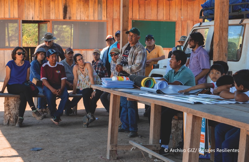
Given the territorial disputes, governance fragmentation, and economic pressures in the Chiquitanía landscape, the creation of MSPs could foster dialogue and cooperation among diverse actors including those with conflicting interests. The landscape’s large size and lack of infrastructure, however, made it difficult for stakeholders to engage in collective processes. In total, the watersheds cover 61,034 km², so to facilitate management of this immense landscape, the project subdivided the three watersheds (Paraguá, San Martín and Zapocó) into eight smaller sub-watersheds. Within these sub-watersheds, Paisajes Resilientes established or reactivated eight management committees at the sub-watershed level based on local governance structures. The committees included rural communities, municipal authorities from San Ignacio de Velasco and Concepción, NGOs providing technical support, and the private sector, such as producer associations focused on agriculture, forestry, and ranching. These committees coordinated efforts to implement sustainable water and resource management activities in the region. This multi-stakeholder collaboration facilitated more inclusive decision-making, jointly coordinated planning instruments, and integrated local knowledge with formal governance structures.
Additionally, the Paisajes Resilientes project launched participatory governance initiatives under the Programa de Gestión de Agua para la Vida (Water Management for Life) programme, which played a key role in promoting water governance in the Chiquitanía. The programme helped facilitate coordination among stakeholders, and the development of a water and climate action and finance plan with short, medium and long-term goals. It worked to balance conservation and livelihood needs, and integrate traditional Indigenous governance systems with technical conservation approaches to enhance water security on local terms.
Common vision
Achieving sustainable ILM outcomes should start with the formulation of a shared vision that reconciles the diverse – and, at times, conflicting – interests of key stakeholders.
When Paisajes Resilientes entered the Chiquitanía landscape, there was no explicit shared vision developed with all stakeholders to guide the ILM processes. It was, however, clear that there was an implicit one.
The Paisajes Resilientes approach focused on defining objectives that aligned with the local realities of sustainable resource management and governance. During the design phase, project staff worked with representatives of the Santa Cruz Departmental government and other stakeholders to identify the Paraguá and San Martín watersheds as priority areas for integrated watershed management due to the impacts of wildfires in the Chiquitanía area in 2019. During the initial stages, local stakeholders lobbied to include the Zapocó sub-watershed in the landscape because it was an important source of water for the municipal capitals. The shared interests in water security provided an implicit foundation for a common vision rooted in the protection of Indigenous knowledge systems and cultural heritage for sustainable livelihoods that could complement biodiversity conservation.
The vision places water as the central unifying element, reflecting its cultural, ecological, and economic importance in the region. As a Paisajes Resilientes representative shared, “Water is simultaneously the connecting thread and the solution that unites all inhabitants.” The project implementation process was supported by dialogue and workshops incorporating the Chiquitano cosmovision. Storytelling helped participants illustrate the interconnectedness of land and water systems. This collaborative effort resulted in a vision document signed by over 200 community members and organizations, symbolizing a collective commitment to sustainable landscape management. Later, Paisajes Resilientes surveys showed that 85% of participants felt more connected to the project after contributing to the vision. The document was revisited in management committee meetings to address evolving challenges, ensuring that it remained responsive to issues like droughts and resource conflicts.
Despite initial challenges due to the absence of a predefined, explicit vision, the project’s flexibility allowed the vision to emerge organically, emphasizing the value of open-ended objectives that evolve with community needs.
Institutionalization
For landscape interventions to endure, effective participatory, adaptive and cross-sectoral planning and decision-making processes should be embedded within existing institutions and systems. In practice, institutionalization of ILM can be a challenge.
The Paraguá and San Martín River watersheds are a recognized geographical/biophysical unit, but as a landscape they do not form a discrete administrative or governance area. The watersheds overlay multiple jurisdictions, falling within the municipalities of San Ignacio de Velasco, Concepción, Urubichá and the San Miguel de Velasco, all of which fall within the Santa Cruz Department. This creates a complex mosaic of political jurisdictions, which complicated governance in the landscape.
Conservation areas and Indigenous territories each with sustainable use regulations reinforced the protection of critical water sources and embedding conservation measures into local governance statutes. The Noel Kempff Mercado National Park, which has existed for decades, flanks the landscape to the east. The Bajo Paraguá TCO (a type of Indigenous communal property) covering the northern edge of the landscape provides a different model of landscape governance. TCOs have representative governance organizations and management rights and responsibilities over natural resources within their territories. The TCO implementation process institutionalized customary practice by respecting and integrating Indigenous governance systems for local decision making. Indigenous leaders established traditional rules for resource use, which were incorporated into formal governance frameworks. This recognition of ancestral knowledge reinforced the legitimacy of governance decisions and strengthened the community’s connection to the project’s initiatives.
The Paisajes Resilientes project supported the development of policy frameworks to facilitate improved ILM, including the Santa Cruz Government’s Departmental Plan for Water Security and Climate Change and its Territorial Plan for Comprehensive Development, aimed at improving watershed management through collaboration with local stakeholders. Conservation areas with sustainable use regulations were also established, embedding conservation measures into local governance structures. Partnerships played a central role in institutionalizing the project’s efforts.
To support strategic decision-making and resource management, the Paisajes Resilientes project helped develop the Integrated Environmental Monitoring System (SIMA) – a public data platform designed to support evidence-based decision-making on climate resilience, natural resource management, and risk reduction. SIMA is a platform for collaborative monitoring and decision support for climate change and water security issues. It provides a freely accessible, centralized source for water and environmental data for improved planning and risk management with up-to-date information.
SIMA draws information from two automated weather stations in the San Martín and Paraguá basins and provides a framework allowing governmental agencies, universities, NGOs, and local communities to upload information related to water sources, water quality, fires, deforestation and restoration activities in areas impacted by fire. By involving these diverse stakeholders, participants ensured that the platform reflected the territorial realities and created a strong foundation for long-term ownership. SIMA has evolved further with the establishment of a participatory monitoring network, which collects local data on groundwater and surface water conditions, as well as hydro-meteorological information. This community-generated data enhances local ownership and improves the system’s accuracy. In parallel, SIMA incorporated a climate change and water security monitoring module, designed to strengthen enabling conditions for climate finance. By aligning data collection with the requirements of national climate commitments and municipal planning processes, the platform contributes to better risk management and opens the door for new investments in resilience.
Once operational, Paisajes Resilientes transferred SIMA to the Santa Cruz Departmental government’s Secretariate of Sustainable Development and Environment. Bolivia’s Catholic University created the Research Center for the Sustainable Development of Eastern Bolivia to act as the technical arm for SIMA. The municipal governments of Concepción and San Ignacio de Velasco passed water conservation laws that recognized SIMA as the official tool for information management.
The Paisajes Resilientes project also supported the creation of two financial mechanisms to support water management in the region. One. the Chiquitanía Water Fund, is a public-private partnership to fund water-related projects, such as potable water systems and cost benefit analysis for infrastructural investments. The second is a credit line for sustainable and deforestation-free livestock production which supports pilot projects to test innovative production strategies for ranches in the region. Both mechanisms are administered by the Bolivian Development Bank.
To seek sustainability for the ILM approach, the project implemented capacity-building programmes targeting subnational and local governmental agencies and local stakeholders. Training was intended to strengthen both technical and soft skills for planning related to water resource management, water governance, and climate adaptation. These various training programmes empowered over 200 local stakeholders (60% women), fostering a new generation of leaders capable of sustaining governance processes at community and municipal levels.
Despite challenges like political transitions and limited resources, embedding ILM strategies in municipal plans and aligning them with national policies created resilience, ensuring the sustainability of governance frameworks beyond the project’s timeline.
Iterative learning and adaptation
The Paisajes Resilientes approach of dividing the landscape into sub-watershed management units allowed the project to focus on more manageable areas while maintaining a broader, integrated perspective. Efforts to address governance were concentrated on four of the sub-watersheds, enabling tailored interventions that reflected local environmental and social conditions. This improved stakeholder engagement and created opportunities for participants to influence governance processes.
Regular feedback loops and constructive dialogue within the management committees enabled stakeholders to assess outcomes from project interventions collaboratively. The project’s consultations with these committees informed the selection of initiatives, ensuring these responded to local realities. Continuous dialogue allowed the project to adapt and scale successful practices, empowering communities to take ownership of solutions and building trust in the governance process. One example was the leadership development programme for community water governance, created in response to identified capacity gaps. Over 120 leaders were trained, many going on to become active figures in local governance. Similarly, a women’s leadership exchange expanded from a single event to multiple sessions due to growing demand and participation. This emphasis on women’s leadership not only empowered participants but also enriched governance processes by fostering diverse perspectives and inclusive decision-making.
The project also implemented five different pilot initiatives to test and refine ecosystem-based adaptation measures, such as introducing agroecological practices with women-led groups and improved silvopastoral systems. With small- and medium-sized ranchers, they explored water management practices like the design and rational use of cattle tanks (“atajados”). Alternative financial mechanisms that addressed the limited access to credit among ranchers (only about 30% had access to credit prior to these programmes) supported these efforts which incentivize sustainable land-use practices.
While Paisajes Resilientes’ approach faced challenges due to political turnover and resource limitations, the project’s focus on continuous learning and community-driven feedback allowed governance structures to remain resilient and responsive to evolving needs.
Conclusions
The Paisajes Resilientes in the Chiquitanía project illustrates the importance of initial stakeholder analysis to classify stakeholders by their influence, interests, and interactions within the landscape. This facilitated the identification of strategic alliances from the outset with continued collaboration among stakeholders after the project ended. For example, two national NGOs, CIPCA (Centro de Investigación y Promoción del Campesinado) and FCBC (Fundación para la Conservación del Bosque Chiquitano), continued to support interventions such as the promotion of agroforestry systems.
MSPs that included diverse stakeholders from the private sector, public agencies and civil society presented challenges to accommodate distinct agendas but also to adopt appropriate language. In this experience, the private sector was primarily interested in specialized technical issues and related cost-benefits analysis. The public sector sought alignment with national development and climate change objectives. Civil society and Indigenous organizations sought security in their resource rights. Because communities were key stakeholders, the approach to multi-stakeholder processes required adoption of less technical language, translators and use of examples from their daily life.
Effective landscape governance starts by working with existing local institutions and practices, and adapting to existing social and environmental dynamics rather than imposing new structures. Channelling ILM discussions through the sub-watershed management committees facilitated interaction and maintained a strong focus on locally relevant issues. This approach illustrated the efficacy of strengthening existing structures and initiatives instead of creating new ones. Facilitating constructive dialogue and regular feedback sessions within the management committees further encouraged iterative learning and contributed to the planning of management activities. The Paisajes Resilientes capacity-building approach emphasized ‘learning-by-doing’ and knowledge exchange, ensuring that management interventions focused on relevant issues for participants at different scales and were more closely tailored to local contexts.
Overall, the Paisajes Resilientes experience demonstrates that ILM is most effective when it is grounded in local realities, builds on existing governance structures, and fosters inclusive, multi-stakeholder collaboration. By centering water as a unifying element, strengthening sub-watershed management committees, and promoting iterative learning through participatory processes, the project enhanced coordination, equity, and local ownership. These approaches not only improved resilience and resource governance during implementation but also created durable institutional foundations capable of sustaining landscape-level outcomes beyond the project’s lifetime.
Published May 2026. For more ILM case studies, see landscapesfuture.org/ilm-case-studies/. All photos courtesy GIZ.