By Natalia Cisneros, Peter Cronkleton and Dominique le Roux (CIFOR-ICRAF), Mario E Rueda Hernández, Héctor M Martínez Viloria, Juan Felipe Lazarus, Ángela P Barrero Hernández and Anny P Zamora Bornachera (INVEMAR), Marcela Galvis Hernández and Martín Gaona (FAO Colombia)
The Paisajes Sostenibles (Sustainable Landscapes) project was developed to address the complex environmental and governance challenges of the Ciénaga Grande de Santa Marta (CGSM), Colombia’s largest coastal wetland system. Coordinated by FAO and implemented with Colombia’s Marine and Coastal Research Institute (INVEMAR), the Ministry of Environment and Sustainable Development and WWF, and funded by the European Union under the Herencia Colombia programme led by Colombia’s National Natural Parks, the project worked across sectors and scales. ILM provided a framework for engaging government institutions, artisanal fishing communities, women’s enterprises, civil society organisations and private-sector actors around shared challenges, particularly water governance and ecosystem restoration.
A central focus of the project was rebuilding relationships among historically marginalized stakeholders and institutions whose interactions had been weakened by conflict, displacement and inconsistent institutional presence. Through inclusive, participatory processes, the project supported the emergence and strengthening of multi-stakeholder platforms, facilitated dialogue across fragmented governance spaces, and promoted collective problem-solving.
The project also demonstrated the value of adaptive and iterative learning. Technical solutions – including innovations for macrophyte removal and fisheries management – were co-designed and tested with communities, allowing environmental objectives and livelihood benefits to be aligned. In some cases, these solutions evolved into independent, income-generating activities led by community groups.
While trust-building and institutional consolidation remain ongoing challenges, the CGSM experience illustrates how ILM can support more coordinated, participatory and resilient approaches to landscape governance in complex social-ecological systems.
About the landscape
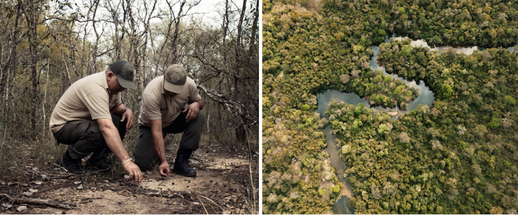
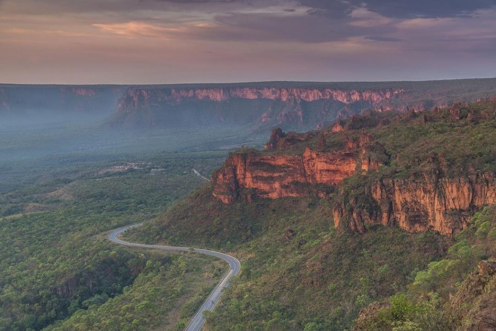
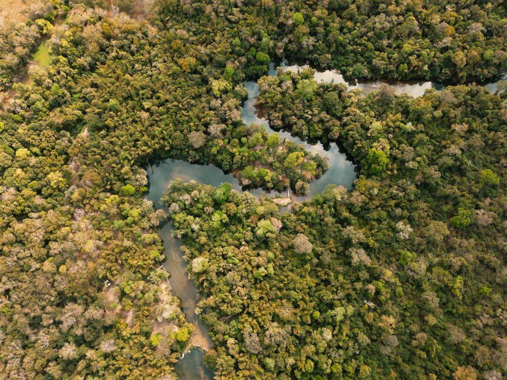
The Ciénaga Grande de Santa Marta (CGSM) is the largest coastal estuarine system in Colombia, located mainly in the department of Magdalena in the Colombian Caribbean. It is a Biosphere Reserve and Ramsar site, covering more than 500,000 hectares and providing key ecosystem services such as fisheries, water regulation, carbon sequestration, biodiversity conservation, scenic beauty and cultural identity for its inhabitants.
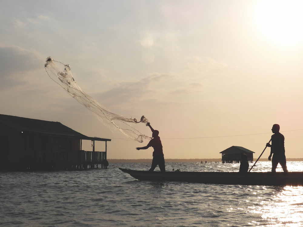
The wetlands support more than 4,000 artisanal fishing families across 26 surrounding municipalities, including palafitic and mainland communities whose livelihoods and food security depend directly on the health of the ecosystem. These communities hold deep ancestral knowledge of estuarine dynamics and recognise the close interdependence between ecosystem functionality and human wellbeing.
Despite its importance, the CGSM faces significant environmental pressures. Infrastructure development – particularly road construction that has blocked natural water inlets – has disrupted hydrological connectivity and altered salinity regimes, contributing to mangrove degradation
and the proliferation of macrophytes. These impacts are compounded by unregulated
agro-industrial expansion, overfishing and
water pollution, resulting in widespread loss
of ecosystem functionality.
These environmental challenges are aggravated by a lack of effective governance among government institutions and local actors. Armed conflict and drug trafficking have generated displacement, conflict and general distrust, weakening the social fabric and limiting collaboration. As a result, relationships between institutions and communities have often been fragmented, reducing the legitimacy and effectiveness of environmental management efforts.
The CGSM is governed through a complex institutional framework. As a Ramsar site and Biosphere Reserve, it is subject to national and international conservation commitments and includes two protected areas administered by Colombia’s National Natural Parks. Responsibilities for water management, fisheries, environmental regulation and territorial planning are distributed across multiple entities operating at different scales. While these mandates are complementary, limited resources, institutional fragmentation and high staff turnover have constrained their effectiveness.
In response to this context, the Paisajes Sostenibles project was developed to strengthen environmental governance and support more coordinated approaches to landscape management. While trust-building among actors remains a work in progress, the project sought to promote inclusive collaboration across scales and sectors, recognising that long-term sustainability in the CGSM depends on reconnecting ecological processes, institutions and the people who depend on them.
ILM dimensions in the Ciénaga Grande de Santa Marta
The ILM approach enables analysis of how different dimensions emerge and influence the success of complex territorial interventions. ILM promotes coordination among diverse actors, sectors, and levels of governance, structured around six key dimensions:
- stakeholder identification and engagement
- promotion of multi-stakeholder processes
- development of a common landscape vision
- institutionalization of governance mechanisms
- adaptive and iterative management
- development of context-specific technical and policy solutions
This case study considers the Paisajes Sostenibles through the first five of these dimensions, while the sixth is integrated through this case study. The following sections illustrate how these dimensions were present in different aspects of the project, generating key lessons for the sustainability and governance of the CGSM.
The ecosystems present in the CGSM are critical to its inhabitants, who depend on them for food security and income. By applying ILM, the Paisajes Sostenibles project has worked to address environmental degradation while strengthening the resilience of local communities through collaborative efforts.
Stakeholder identification
The knowledge that INVEMAR has accumulated over more than three decades of research and coastal monitoring in the CGSM, along with its institutional presence in the area, has been key to identifying relevant actors and facilitating governance processes from the beginning of the project. INVEMAR builds on work conducted under a previous project, Local Sustainable Development and Governance for Peace (LSDGP), funded by the European Union. This provided a starting point for identifying fishing communities, women’s associations, and community leaders. That experience showed INVEMAR and its partners the need to address land and water use challenges comprehensively across a broader geographic scope.
Artisanal fishermen are key actors, supporting more than 4,000 fishing families – whether organized in associations or working independently – dispersed across 26 municipalities surrounding the Ramsar site. Among them are communities such as Buenavista, Bocas de Cataca and Nueva Venecia, representing an amphibious culture and holding ancestral knowledge on the ecosystem’s dynamics, where fishers are aware of the interdependence between ecosystem health and population wellbeing.
An example of collective organization among the fisher folk is the Association of United Artisanal Fishermen for the Restoration of Puerto Caimán (ASOPCAIMAN), a group that responsibly catches jaibas (blue crabs, Callinectes spp.) to supply a company that processes, cans and exports crab meat. Another type of local stakeholder group is the various community-based tourism initiatives. Many of these are led by women and aim to diversify income while conserving the landscape and its biodiversity.
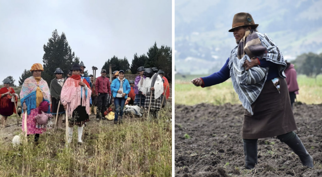
During the stakeholder identification process, local initiatives were mapped, including Mangle Mi Huella Verde (‘Mangrove: My Green Footprint’), an enterprise dedicated to transforming single-use plastic, that was strengthened through the Paisajes Sostenibles project. Women’s enterprises were also identified. Although women were often excluded from fishing themselves, they have taken on key roles in product transformation and business management, contributing to greater gender equity within these value chains. One such enterprise is the Environmental Foundation of Women of Magdalena (FUNDAMAG), which works in tourism and CGSM mangrove restoration, involving technological innovations such as the use of a machine developed during project implementation for the collection and processing of macrophytes — large aquatic plants used for handicrafts.
Large agribusinesses producing banana, oil palm, and livestock are also influential players in the region due to their economic power and their role in generating significant employment. However, they have also been sources of conflict – mainly environmental – related to the inappropriate use of water and contribution to pollution from fertilizers, which seep into water bodies.
Governmental institutions are generally welcomed by the communities, although few are widely recognized in the area. INVEMAR, however, is well known due to its continuous presence in the territory, direct communication, and scientific support for decision-making, and has generated trust and close links with local stakeholders.
The Ministry of Environment and Sustainable Development (MinAmbiente), as the authority that defines the country’s environmental policy, is responsible for the administration of the Ramsar site and the Biosphere Reserve and is therefore central to formulating regulatory frameworks. Colombia National Natural Parks (PNNC) is attached to MinAmbiente, and administers the two protected areas that make up the Biosphere Reserve’s Core Zone: the CSGM Flora and Fauna Sanctuary and the Salamanca Island Parkway. Although both parks have complementary environmental mandates in the territory, the management complexity in the region exceeds PNNC’s technical, operational, and financial capacities.
The Magdalena Regional Autonomous Corporation (CORPAMAG) is the regional environmental
authority and plays an important role in the imple-
mentation of environmental policy in territorial management. It has, however, faced difficulties
given the magnitude of the socio-environmental challenges in the region. This has complicated its ability to collaborate closely with local communities, which has affected their perception of its role.
The National Aquaculture and Fisheries Authority (AUNAP), attached to the Ministry of Agriculture and Rural Development, is responsible for managing the country’s fisheries and aquaculture resources. AUNAP’s direct presence in the landscape is limited, which has made it difficult to effectively manage resource use with local stakeholders. It has, however, worked hand-in-hand with INVEMAR to use fisheries monitoring results for management.
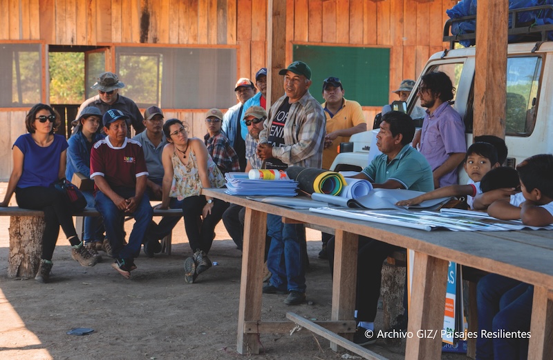
Multi-Stakeholder Processes
Among the project’s initial activities were efforts to support the development of governance schemes in the territory. As the work progressed, however, it became clear that many of the existing coordination spaces fulfilled more formal, technical or institutional functions, but rarely enabled active or continuous participation by local stakeholders. As a result, these local actors rarely participated in collective dialogues.
To respond to the central challenges related to water throughout the landscape, the project promoted the creation of a governance scheme that is now known as the Territorial Water Council, a structure that acts as an umbrella for six Territorial Water Boards. The Territorial Water Council was formalized by the Ministry of the Environment. It represents a strategic model of governance that integrates different levels and types of actors with a common agenda around water and ecosystem sustainability.
Among the Multi-Stakeholder Platforms (MSPs) relevant to this project, the following may be
highlighted:
The Coordination Committee for the Integrated Management of the Ciénaga Grande de Santa Marta, created by a MinAmbiente resolution, has historically been a technical and institutional space with the participation of national and regional stakeholders. Despite its key role in defining restoration and conservation strategies for the Ramsar site, its actions are perceived as distant from community dynamics. Decision-making in this space has been limited by the lack of institutional continuity.
The Territorial Water Council (CTA) is one of the project’s most relevant innovations. The CTA is a consolidated space for coordination among multiple stakeholders in the territory. Under its structure, six Territorial Water Boards were formed, comprising communities, and including producers, NGOs and local institutions. These roundtables support the design of participatory territorial plans and seek to implement conservation, restoration and monitoring agreements. The initiative also seeks to build trust between historically segmented sectors, and to mediate socio-environmental conflicts.
The Water Stewardship Platform is an intersectoral alliance initially promoted by WWF that facilitates community monitoring and protection of water resources in key areas such as the Frío and Sevilla rivers, and functions as a benchmark for its participatory and intersectoral model. The Paisajes Sostenibles project was able to incorporate the Fundación and Aracataca River basins into the initiative, although with different levels of maturity and autonomy. These initiatives laid the groundwork for broader community governance processes.
The interaction with these platforms allowed the project’s actions to have greater local legitimacy, strengthened community leadership and facilitated the creation and follow-up of commitments. There are still, however, significant challenges to consolidating effective environmental and territorial governance, such as the frequent rotation of public officials, the absence of local authorities in key areas, and power imbalances among stakeholders. These problems appeared in communities such as Bocas de Cataca y Remolino, where the lack of organization, representation and clarity about their own demands limited their institutional consolidation in comparison to communities with more advanced organizational processes, which generated asymmetries in decision-making spaces.
Common vision
Although the Paisajes Sostenibles project was not born with a common vision for the landscape, it was based on a clear concern for a shared problem: the loss of the ecosystem functionality of the Ciénaga and the disconnection among those who depend on it. This clarity, inherited from INVEMAR’s experiences and the LSDGP project, made it possible to establish a common basis for moving towards collective agreements.
The alignment of a common vision was the result of multiple processes, both formative and participatory, including ongoing exchanges of experience, technical roundtables, community workshops and co-creation exercises led by the Paisajes Sostenibles project. Although interests and priorities were initially local and short-term, the project facilitated spaces where local stakeholders recognized interdependencies, especially between upstream and downstream communities, as well as different geographic zones of the Ramsar site.
Although visions of the landscape vary from territory to territory, several commonly valued elements emerged:
The urgent need to restore the mangrove ecosystem as a strategy to contribute to the local economy (e.g., artisanal fishing, birdwatching, amphibian culture livelihoods).
The need to value the traditional knowledge of local fishermen and strengthen artisanal fishing as the main economic and cultural activity in the region, as well as their role in ecosystem balance.
The importance of improving water governance, particularly in terms of availability and accessibility.
The need for more transparent, cross-sectoral and inclusive multilevel and multi-stakeholder governance.
Although the common vision provided a useful point of reference, gaps have persisted in terms of the mechanisms to implement it: the lack of leadership, tensions between institutional mandates, and barriers to aligning agendas between scales. In addition, there was evidence of a strong historical dependence on external projects, which in some cases reinforced dynamics of institutional paternalism. This situation has generated additional challenges for local ownership of the processes, especially in contexts where the continuity of efforts is conditioned by external financing or technical support.
Institutionalization
The Paisajes Sostenibles project sought to anchor its actions in existing landscape structures, recognizing their normative and symbolic value. The CGSM has a solid institutional framework: it is a Ramsar Site, a Biosphere Reserve, and includes two protected areas, all of which require effective coordination between entities and management that complies with international commitments.
The project supported the strengthening of the Ramsar Committee to link advances in territorial governance with national and international conservation commitments. This effort included updating the shared vision on water management, community participation and ecosystem planning. As a result, the project constructed a technical and participatory roadmap to guide the implementation of the Ramsar site management plan. Although INVEMAR had previously updated the plan, and clear recommendations were made in 2022, the roadmap has not yet been officially adopted. There are administrative bottlenecks and a lack of institutional leadership among the responsible national bodies, MinAmbiente and CORPAMAG. This delay is particularly sensitive because even some community stakeholders believe that the process has been formally approved, given that the preparatory work is complete, and the level of participation involved.
One of the most important challenges at present is the formal institutionalization of the Territorial Water Council, a structure already created, operational and with local legitimacy, which has demonstrated its value as a multi-stakeholder governance space. Despite its functioning and the recognition it has received even at the national level, the lack of tools to facilitate its operation — as well as that of similar spaces in the region — has limited its sustainability and capacity for long-term impact. In this context, it is hoped that an incoming project financed by the Global Environment Facility (GEF), GEF7-CGSM, will give continuity to several of the governance processes in the area, and will contribute to the consolidation of pending institutionalization by integrating the Council into formal water and environmental management schemes at the national level.
Despite these advances, structural barriers persist, such as institutional fragmentation, high staff turnover in key entities (such as CORPAMAG or some local mayors’ offices), and a lack of sustained financial and human resources. Many local authorities lack trained technical staff and adequate budgets to implement the collectively constructed agreements.
Iterative learning and adaptation
In a landscape as dynamic and complex as that of the CGSM, it was necessary to adapt to new socio-environmental realities, incorporate emerging lessons and adjust work methodologies based on local knowledge and experience.
One of the underlying causes of ecosystem degradation has been the proliferation of macrophytes, largely triggered by changes in water salinity. These changes occurred after road infrastructure, particularly the highway, blocked most natural inlets that previously allowed seawater to enter with the tide. This loss of connectivity disrupted estuarine dynamics and contributed to the excessive growth of floating aquatic plants.
In this vein, restoration work with the community identified the proliferation of macrophytes as an urgent problem, as it affected both navigability and ecosystem health. Previously, macrophytes were collected by hand. Working with the communities, the technical team co-designed a machine to mechanise this process. Through this collaboration, approximately one ton of macrophytes was collected during a two-hour pilot test. The solution proved so effective that the community group that led this initiative now offers independent waterway clearing services for transportation, generating their own income.
An emblematic case of adaptive management was the adoption of modified traps used in the crab fishery. These mesh boxes had been designed to allow individuals that have not yet reached sexual maturity to leave the traps. INVEMAR observed, however, that some fishermen sealed these windows to maximize their catches. This suggested that the functionality of the traps — and their ecological value — had not been appropriated by the users who did not understand the potential value of the traps for the ecosystem, and so continued to prioritize individual short-term gains.
As a result, the use of the traps was temporarily suspended, and participatory experiments with the fisherfolk were designed. These showed that when small crabs were released, the average size of the catch increased. This evidence allowed fishers to understand the benefits of the practice, which led to its voluntary adoption. This case reflected the importance of iterative learning: it is not enough to introduce technical solutions if they are not understood and internalized locally. For practices to be sustainable, they must be built on dialogue, contextual evidence, and collective validation.
Active participation continued through feedback sessions, mentoring, and context-specific dialogues, which allowed strategies to be adjusted based on field experience. In the palafitic communities, priority restoration zones were, for example, redefined according to community interests. Water quantity was also monitored with the knowledge of local actors, who helped to interpret changes according to tidal cycles, rainfall, or waste discharge.
The efficacy of these learning cycles depends largely, however, on the strength of relationships built through previous trust-building efforts. In areas where historical exclusion or legacies of conflict persist, communities often fail to engage meaningfully without sustained facilitation.
Conclusions
The experience of the Paisajes Sostenibles project in the CGSM shows that ILM requires not only technical tools and solutions, but also long-term trust-building processes. This is not generated by decree: it is based on concrete examples, on seeing-to-believe, and learning-by-doing. The case of the blue crab traps showed that, when beneficiaries directly experience technological changes, transformations are possible and sustainable. This logic is also reflected in the relationship between INVEMAR and the communities: its territorial presence, technical coherence and capacity to listen have generated solid links that have served as a bridge with other institutions. Trust has allowed previously disconnected actors — such as national entities and artisanal fishers — to begin collaborating and recognize each other as valid partners. In a context marked by historical inequality and mistrust, this process represents a realistic and transformative basis for moving towards resilient and inclusive landscapes.
Published May 2026. For more ILM case studies, see landscapesfuture.org/ilm-case-studies/. All photos courtesy of INVEMAR.