By Natalia Cisneros, Peter Cronkleton and Dominique le Roux (CIFOR-ICRAF; Patricia Roche, Valentina Bedoya, Andrea Garay, Karim Musálem and Aida Luz Aquino (WWF Paraguay)
The CERES1 project in Paraguay’s northern Chaco Cerrado shows that ILM can work even in extreme conditions – if actors are willing to adapt, use informal coordination creatively, and prioritise legitimacy over rigid blueprints.
This case is not simply about conserving a rare and threatened ecosystem. It is about building governance in a vacuum: establishing the first permanent State presence in a territory previously managed at a distance, supporting Indigenous Ayoreo communities in reconnecting with their ancestral lands, and finding ways for ranchers, civil society, and government to collaborate despite deeply divergent interests.
For donors, it demonstrates how investment in facilitation, institutionalization, and community participation can yield durable gains – such as the legal titling of Cerro Chovoreca Natural Monument – that would otherwise have been out of reach.
For practitioners, the lessons are equally sharp. The project shows the value of neutral facilitation in contested spaces, the importance of informal mechanisms (from WhatsApp groups to ad-hoc meetings) for keeping decisions moving, and the need to accept symbolic progress – such as periodic visits to ancestral lands – when permanent solutions are not yet possible. Above all, it highlights that ILM is less about perfect plans and more about adaptive learning, trust-building, and anchoring small steps in lasting institutional change.
About the landscape
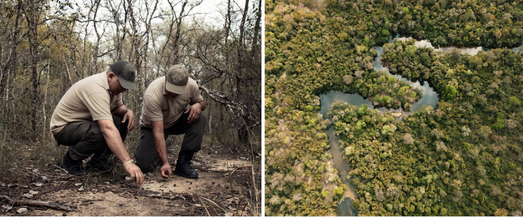
The Chaco Cerrado is Paraguay’s last green frontier. Despite its immense ecological value, it is one of the country’s most threatened and least- known ecosystems. It represents one of the only portions of the Cerrado biome in Paraguay and is located at the convergence of distinct ecoregions – the Dry Chaco, the Pantanal, and the Cerrado itself – forming a unique mosaic of biodiversity and cultural richness. This region is part of the ancestral territory of the Ayoreo people, including both contacted communities and others in voluntary isolation, whose traditional practices and worldviews are deeply connected to the landscape.
Conditions in and around the Cerro Chovoreca Natural Monument (CCNM), located in the district of Bahía Negra, are extreme. The intervention area lies in one of the most remote regions of Paraguay, with limited human settlement, connectivity, infrastructure, or the State’s public presence.
These territorial constraints significantly challenge conservation efforts and sustainable development – it is difficult to access, even by park rangers, suffers from water shortages, and is highly vulnerableto wildfires. Although Bahía Negra contains the largest number of protected areas in Paraguay and is part of the Chaco Biosphere Reserve, its isolation has limited State action and made governance difficult. Furthermore, the lack of surface water has prevented the Ayoreo Chovoreca community from inhabiting and maintaining a permanent presence in their territory, despite their desire to do so.
Meanwhile, the region’s livestock sector is highly developed.
In response to these conditions, the CERES Project was launched in 2020 – an international initiative led by WWF Netherlands and implemented in Brazil (by WWF Brazil and the Institute for Society, Population and Nature) and Paraguay (by WWF Paraguay) with funding from the European Union. Although the project was implemented in both countries, this case study focuses on activities in Paraguay. Until its closure in 2024, CERES promoted an inclusive and sustainable development model aimed at empowering local communities, strengthening institutional capacities, influencing public policy, and raising awareness of the Cerrado’s value through participatory strategies and communication campaigns.
One of CERES’s areas of intervention included the CCNM, the surrounding Agua Dulce area, and the Chovoreca Garaigosode Ayoreo Indigenous Community. The topography is predominantly flat with slight changes in elevation near the border with Brazil. The landscape is characterized by low population density and high strategic value for ecological connectivity with other areas, such as Defensores del Chaco National Park – the largest protected natural area in Paraguay.
ILM dimensions in the Cerro Chovoreca Natural Monument landscape
The ILM approach enables analysis of how different dimensions emerge and influence the success of complex territorial interventions. ILM is an approach that promotes coordination among diverse actors, sectors, and levels of governance, structured around six key dimensions:
- stakeholder identification and engagement;
- promotion of multi-stakeholder processes;
- development of a common landscape vision;
- institutionalization of governance mechanisms;
- adaptive and iterative management; and
- development of context-specific technical and policy solutions.
This case study examines each of these dimensions, although the sixth – tailoring solutions to local needs – is not addressed separately, as it is embedded throughout the description of the project’s actions and strategies. The following sections illustrate how, specifically in the CERES project in Paraguay, these dimensions were present in different aspects of the work, generating key lessons for the sustainability and governance of the Cerrado.
Stakeholder identification
The Cerrado landscape in Paraguay’s northern Chaco brings together diverse stakeholders with varying levels of involvement, interests, and capacity for action.
Before CERES, many stakeholders had no sustained physical presence in the area due to its remoteness, inaccessibility, and lack of basic infrastructure, which hindered governance and inter-institutional coordination.
The Ministry of Environment and Sustainable Development (MADES), responsible for managing protected areas, had no permanent presence in the area. At MADES’ request, CERES established a mobile control post for park rangers – marking the first time the State maintained a continuous operational presence there. MADES was also interested in advancing the legal titling of the Cerro Chovoreca Natural Monument to consolidate and formalize the protected area.
The Ministry of National Defence maintained a presence via nearby military bases. The National Institute for Rural and Land Development (INDERT2) holds legal ownership of the CCNM, which needed to be transferred to MADES for formal recognition as a protected area.
The Paraguayan Indigenous Institute (INDI3), which is tasked with ensuring the legitimate representation of Indigenous communities, played a key role in validating their participation in this highly sensitive context, as communities in voluntary isolation also inhabit the area.
Extensive cattle ranching is one of the most influential sectors in the Chovoreca landscape. The Agua Dulce Livestock Association (APAD4), which brings together local ranchers, is a key stakeholder and among the few with a permanent presence. Its members control a significant portion of the local economy, with large landholdings and logistical capabilities that grant them influence over both productive dynamics and territorial decisions.
There are also Indigenous peoples with rights and interests in the landscape. The Ayoreo Chovoreca community owns a 20,000-hectare tract historically used for their nomadic livelihoods. Despite holding a titled property, growing territorial pressure led the community to seek a more constant presence in their land to protect it and uphold their rights. They have, however, faced obstacles in returning to and safeguarding their ancestral lands due to climatic conditions, infrastructure gaps, and lack of basic services.
In addition to WWF Paraguay, several civil society groups also work in the landscape, including different NGOs such as Guyra Paraguay, Iniciativa Amotocodie, and Alter Vida.
Multi-Stakeholder Processes
The CERES implementation process in the Chovoreca landscape has been a story of strategic adaptation, marked by learning, re-evaluation, and reconnection.
Initially, WWF Paraguay participated in a multi-stakeholder land-use planning process(POUT5) for Bahía Negra district, which had been active for several years. While this space offered an entry point for landscape dialogue, divergent interests among participants and the perception of WWF Paraguay as a non-neutral facilitator (due to its conservation focus) ultimately stalled progress. The POUT never received municipal approval.
Learning from this, the CERES team (working as WWF Paraguay, since the project identity was less well known locally) redefined its multi- stakeholder strategy. As part of the component for strengthening protected areas, the project shifted to supporting the titling process for Cerro Chovoreca Natural Monument as a first step in a broader strategy to sustain biological corridors. This new phase convened key stakeholders in a multi- sectoral working group that, through effective coordination between civil society, government, and the private sector, achieved a major political milestone: the legal titling of the protected area.
Each actor played a clear role. APAD, WWF, and Guyra Paraguay supported with legal and logistical advice; MADES led the regulatory and technical process; INDERT conducted the judicial land survey; and the Ministry of Defence, the National Boundaries Commission, the National Cadastre Secretariat, the Geodesy Directorate, the National Public Records Directorate, and the Chief Public Notary facilitated the legal transfer and formal registration. This collaboration enabled the official titling of Cerro Chovoreca Natural Monument in June 2024, through INDERT’s transfer of land ownership to MADES. The milestone was publicly announced at an event attended by the President of Paraguay.
With the area now titled, a new multi-stakeholder working group was formed to develop a management plan, with support from an external facilitator to ensure technical neutrality. In this third phase, WWF deliberately took a less prominent role. Hiring an external company facilitated a participatory process impartially and effectively. Additionally, sustained support and funding from CERES and other WWF initiatives enabled the active participation of Ayoreo communities.
Coordination in the titling phase occurred mostly through informal mechanisms – WhatsApp groups, verbal agreements, and targeted meetings – that enabled agile operational decisions. For the management plan, collaboration was structured mainly through field visits, participatory workshops, interviews, and meetings between researchers, authorities, and communities. In both cases, flexible dialogue spaces enabled agreement, later formalized through official resolutions and agreements.
As in similar processes, there was initial hesitation about including new actors, especially given short timelines. Sustained dialogue with the Ayoreo community, however, yielded the opposite: the Ayoreo community’s participation, including during fieldwork, strengthened the legitimacy of the process and enriched the technical content of the plan by incorporating traditional knowledge, sacred sites, historical land uses, and cultural and spiritual landscape values.
This multi-stakeholder process transformed institutional relationships. Communities went from being perceived as obstacles to being seen as key allies, and public actors recognized the value of truly inclusive participation. This laid the foundation for a new model of territorial governance based on mutual respect, the complementary nature of knowledge systems, and shared responsibility.
This process showed that integration does not require everyone to agree from the outset – it requires mechanisms for dialogue, conflict resolution, and convergence toward shared goals. The key was clear rules, defined tasks, and a shared agenda.
Common vision
From the outset, CERES proposed a broad and flexible vision: to conserve a resilient Cerrado through inclusive and sustainable development – even though few people in Paraguay were aware of this eco-region’s existence. This high-level framing allowed the vision to remain relevant throughout the project in both Paraguay and Brazil, without requiring significant adjustments, despite contextual changes and implementation challenges.
In Paraguay, this broadness brought both advantages and challenges. On the one hand, it helped align diverse stakeholders – Indigenous communities, producer groups, public institutions – around the project’s general narrative. On the other hand, the lack of specificity initially limited the development of a shared roadmap or prioritized interventions.
The shared vision did not emerge in a single phase; it took shape through iterative processes, such as those leading to the titling of Cerro Chovoreca and the participatory development of the management plan. In those spaces, actors’ specific interests gradually converged into a shared understanding of the landscape: the need to organize, protect, and collaboratively manage a territory crucial for conservation, ranching, cultural identity, and legal security.
Institutionalization
One of CERES’ most lasting impacts was helping institutionalize processes that were previously scattered or informal. The management plan was approved through a ministerial resolution by MADES, becoming an official tool for managing the protected area. Having been developed with multi-sector participation and validated by Ayoreo representatives, it became a best-practice example for other landscapes and protected areas.
Participants found that informal channels – WhatsApp groups, verbal agreements, and occasional meetings – were effective ways to fine-tune the plan. Once consensus was reached, decisions were formalized through official resolutions, agreements, and internal procedures. The project succeeded in institutionalizing several of these practices, which are now being replicated by public institutions elsewhere in the country.
WWF’s strategy of engaging in pre-existing titling and planning processes showed that projects do not need to create parallel structures but can strength-en existing ones by legitimizing them and enhancing their technical and social capacities. Institutionalization was not a goal in itself, but a means to sustain achievements beyond the project’s funding cycle.
Iterative and adaptive learning
The ILM approach was not a blueprint applied from the start of CERES; it was a practice gradually understood, negotiated, and adapted. The technical team, implementing partners, and local actors essentially learned together what ILM meant in a remote, complex landscape like the Chaco Cerrado.
One of the biggest lessons came when the team realized its original proposal – to establish function- al biological corridors between conservation units – was technically sound but operationally impossible given stakeholder divergences at the time. When the POUT dialogue space stalled, WWF and partners chose not to force implementation. Instead, they chose to highlight the importance of the corridor designation. Through maps, narratives, and dialogue spaces, the idea of ecological connectivity was socially established without imposing formal restrictions. This was not only a tactical shift but a deeper lesson about prioritizing legitimacy over technical imposition.
Another important lesson involved efforts to support the Ayoreo community’s physical return to ancestral lands through the installation of a water well. While infrastructure was delivered, territorial conditions (climate, access, services) didn’t allow for permanent settlement. Far from seeing this as failure, the team understood that symbolic reconnection, periodic visits, and community monitoring were legitimate ways to restore ties with the land – adjusting expectations without abandoning the goal of strengthening Ayoreo- landscape relations.
Finally, the experience of directly facilitating multi-stakeholder spaces – like the POUT platform – highlighted how technical leadership may conflict with the need for neutrality in sensitive processes. Having faced such tensions before CERES, WWF deepened its understanding of the value of neutral facilitation. Thus, WWF/ CERES decided not to lead those spaces directly and instead hired external facilitators, improving perceptions of impartiality and reducing tensions among stakeholders.
All this occurred within the EU project framework, which had predefined objectives, timelines, and components. Yet the team demonstrated strategic flexibility – adapting plans, reframing goals, and reconfiguring alliances – without losing sight of core principles. In summary, CERES did not just apply the ILM approach, but learned by doing. The adaptive learning process was continuous and cross-cutting, allowing the project to stay on course even when the original path had to be redesigned due to territorial realities.
Conclusions
The experience of the CERES project in Paraguay’s Chaco Cerrado demonstrates that Integrated Landscape Management can be effective even in contexts marked by remoteness, weak institution- al presence and deeply unequal power relations. Rather than applying a fixed model, the project showed the value of adapting ILM principles to local realities – prioritizing legitimacy, flexibility and trust over rigid structures or predefined solutions.
In a landscape where governance had long operated at a distance, CERES helped establish the foundations for collective action by strengthening informal coordination, enabling dialogue among unlikely partners, and gradually anchoring these processes in formal institutions. Achievements such as the legal titling of the Cerro Chovoreca Natural Monument illustrate how incremental, well-facilitated steps can unlock durable institutional change, even in governance vacuums.
Equally important are the project’s lessons on adaptive learning. By recognizing when original plans were unworkable, accepting symbolic or partial progress, and valuing neutral facilitation in contest- ed spaces, CERES reinforced that ILM is not about perfect outcomes, but about sustaining processes that allow collaboration to evolve. In this sense, the case highlights ILM as a practice of patience, pragmatism and long-term commitment in complex frontier landscapes.